Monday, January 4, 2010

Days 12 to 16 - Annapurna Circuit

Day 12: Kagbenni to Jomson


After such long days up to the Pass then what we encountered coming over it, having a second day of easy hiking wasn't such a bad idea. We were now totally walking on the road which was dusty, windy and didn't have the greatest of views. As we made it through the 4 or 5 hour walk, we came into this huge, open river delta that had endless amounts of rocks carrying fossils. For the next hour we all were picking up random rocks and smashing them open to find a treasure. Nic found an imprint of a plant but that was about it. It was fun but didn't show for anything. Into Jomsom it was - and Nic and mine's room even had a TV. I have to say that after eliminating that from my life for the past 3 1/2 months it was nice to wither away 2 hours of my life watching trash!! Good Times!

Day 13: Jomson to Kalopani

We were all very happy to get out of Jomsom as it was one of the least favourite places for each of us. There weren't really any places to see, the village seemed 'cold' and un-inviting and the people there never really peaked an interest for me. Take that experience then turn it around and show me the complete opposite - welcome to Marpha! This tiny little village in our journey to the next stop and we come across this small area with very old buildings, cobblestone walkways, a plethora of wood drying on house rooftops and so on... Marpha was a particularly quiet place and the locals were incredibly friendly and humble to have us walk through. We tasted some local apple brandy (of which I bought and now have in Vancouver if any of you would like to try some) and had a snack atop one of the residences.  I highly recommend this place to future travellers as a place to stay a night or two instead of Jomsom as it's very close and you'll get a way better experience from the place.


Day 14: Kalopani to Tatopani

"Tato" means "hot" and "Pani" means "water" = Hot Water = Natural Hot Springs!! Oh ya, that's right... we were going to stay the night at a spot that has a natural hot spring for anyone passing by and with the few people on the trail at the time, we knew that it wouldn't be busy at all.

Passing though villages on the way we checked out a wedding ceremony. This must have been an arranged marriage as the bride was much younger than the groom. It was neat to see their traditions and how show respect and happiness for the couple.  I would never go through with an arranged marriage so I can't say I was happy for these people, but hey, it's their system and their traditions so best of luck to them!


Day 15: Tatopani to Ghorepani

Up and up and up...and up some more! Today we began at the river's edge and we to climb for the entire leg of the day. It was switch back after switch back to get up the hillside and it was tough. With the past few days being very easy, I was excited to have another really tough day so on I went. The incline wasn't guelling but it was consistent. We agreed that today's hike was actually equivillant to FOUR Grouse Grinds. There were hundres of stairs, all uneven in length, height and distance apart from one another making for a tough few hours. We stopped in Sikha Valley for lunch. It's in the afternoon sunshine and was a great place to take off our boots and socks to dry them out while we ate. Of course I ordered Dal Bhat again and powered through it. I'm telling you that if any of you ever want to come over for dinner I will personally make and serve you this amazing dinner!


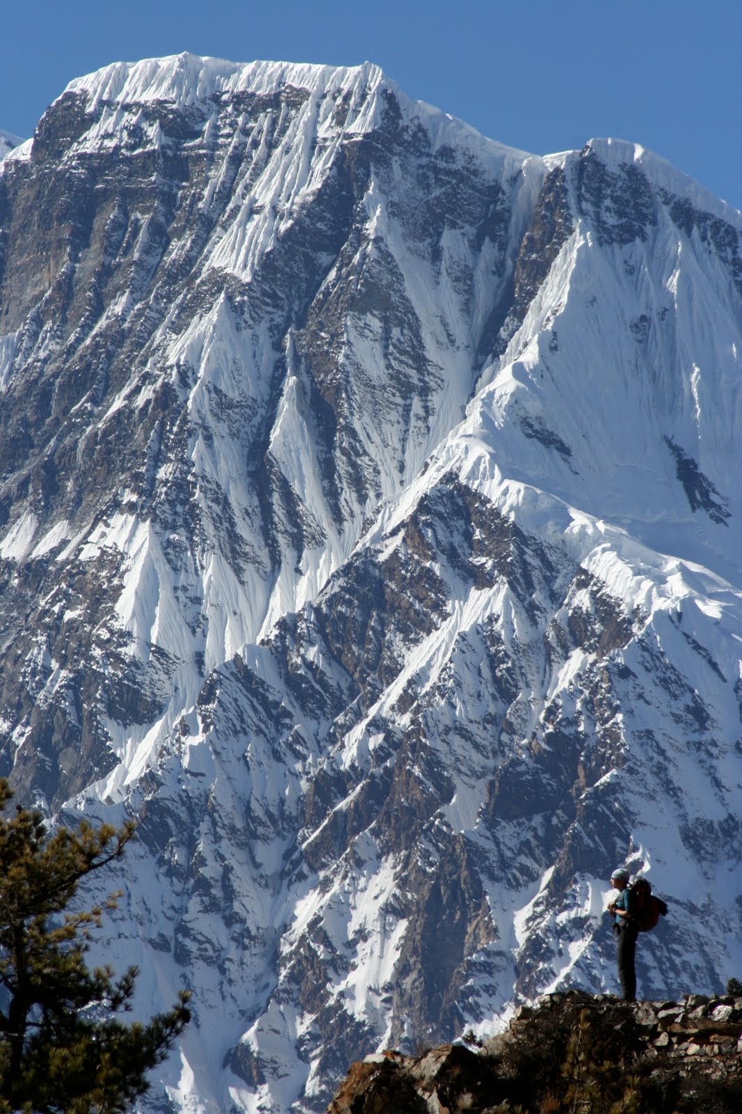
Into Ghorepani - done! We are just below 10,000 feet tonight and can see for miles from where we are. We have a spectacular view of Dhaulagiri and Annapurna South mountain ranges and the tea hut that we're staying at is like a tree house. The wall are paper thin plywood, the ceiling slopes to one side of the house so when you go to have a shower you need to duck down and hunch over to get through and the main room has an awesome fireplace that warms up everyone in it! Great day and we're all happy!


Day 16: Poon Hill / Rest Day

Up at 4:45am and with headlamps on we set out the door for a quick 2 hour hike up to Poon Hill (3210 meters - or just over 10,000 feet). The viewpoint offers panoramic shots of the entire valley, Pokhara area and beyond everything for miles and miles! There was a bit of morning fog in the valley but it set a mood for the photos. It really looked as if we were floating on clouds because they were below us and it was crystal clear higher up.  There might have been 100 people there and that is pretty low considering at peak season they have 500 or so each morning!


More to come ...

Saturday, January 2, 2010

Days 9 - 11: Annapurna Circuit

Day 9: Yak Kharka to High Camp

The morning started off with a heated relationship argument but once that was out of the way things settled down and we got hiking. We walked high above the river making our way higher and higher in elevation towards High Camp where we'd stay the night. So far we've all had very little effect to the altitude and have kept moving fairly quickley but today was a different story. The pace was about normal however we all could feel the beginning effects of going higher up. At lunch in Thorong Phedi Nic was mentioning she had a pretty bad headache so she went right onto Diamox, the altitude drug that balances out the body's pH levels to minimize the effects of altitude. In an hour or so things were feeling much better and the group decided to make the trek higher up one more hour to the circuit's High Camp, lodging at 4800 meters (15,744 feet) to spend the night. At a moment's notice if someone from the group were to show major signs of high altitude cerebral edema (HACE) or high altitude pulmonary edema (HAPE) we would pack up and hike back down to the village below and stay the night.

At the High Camp, I began to feel nauseated and had a wicked-bad headache, something that I hadn't experienced in a long time. Nic and I had an agreement that for this trip there were to be no 'tough guys' who would try to baby their symptoms if shown so I was up front in telling the group how felt and was honest in my emotions. Bill gave me some Diamox and we set a deadline as to how I was feeling and whether or not to stay or go. At 7pm that night I made the decision to stay at high camp as my symptoms were fading and I was feeling much better.  I still don't know how bad I really was feeling but reading my journal excerpt from that night today it was clear that I wasn't feeling good and that I was showing signs of the HACE. None-the-less, the drugs worked very well and I got a well-rested night.

Day 10: Thorong-La Pass to Muktinath (Elevation at pass: 17, 764 feet)


What a day! I will remember this one for the rest of my life! We woke up at 4:30am practically dressed in our hiking gear from the night before as it was just too cold through the night to stay in normal sleeping gear. The temperature inside our rooms read -11 on Dave's barometer and we knew that it was going to get colder at the pass. A quick breakfast and check that all parties were feeling good enough for a 10 hour day and we were off. It took us 2 1/2 hours to make the 616 meter elevation gain to the pass. The trail was icy for part of the way and the wind really made for a cold face. We wore down jackets, gloves, hoods and scarfs to block as much of the wind as possible but it still sent chills down through our bones! Hiking to the pass was tough as there were a lot of false summits. This means that you continuously make it up to a clearing atop a hill and think that it's the end only to find more trail in front of you.  None of the group members had looked online to see what the summit looks like so none of us had a clue what to expect.


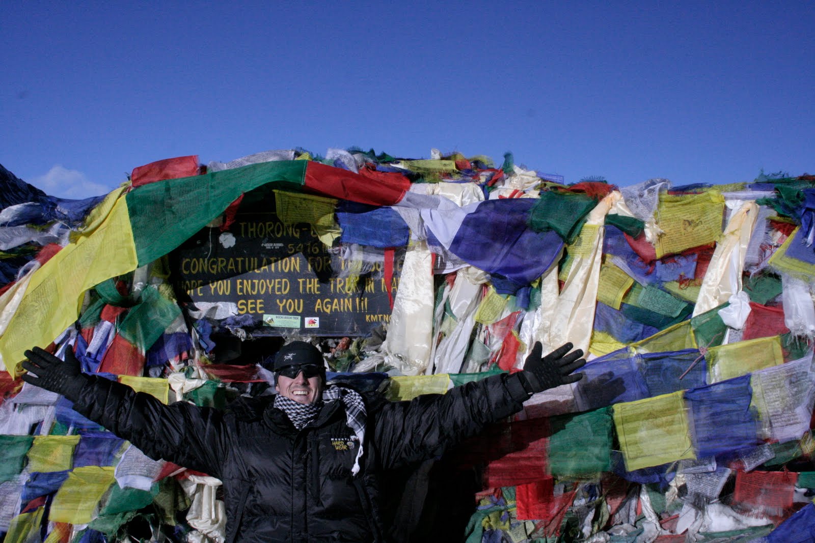
We finally made it to the summit and were welcomed by a barrage of prayer flags and a plaque that congrtulated us on the accomplishment. The sun was shining, skies were totally clear, wind HOWLING and temperature was as close to rediculous as I've ever experienced (must have been -20 with the wind!).  The feeling of making this pass was amazing and was made that much better because I was with the girl I love and some great friends to share the moment! Never had I ever thought of hiking this high so to check this one off my bucket list was a really cool thing. Lots of photos were taken (and are shared on my PICASA webpage) and around 9:30am we were ready to leave. Just at the moment another few hikers arrived and we welcomed them and cheered them on. Unfortunatly, one of the guys totally had some bad luck, slipped and twisted his leg on a sheet of ice. Right away Bill concluded that this guy showed signs of a spiral fracture of the fibula! Crap! A fractured leg on an icy summit pass where there's no chance of getting a helicopter to pick you up - AND an 1800 metre decent to the next village. On the brighter side, this guy couldn't have been luckier in the fact that he just fractured his leg in the presence of an ER doctor with other strong men around to help him down the mountain! The next few hours for me were grueling as I helped carry this guy partially down the trail. It was very icy in some sections and the grade of decent was unforgiving. I had on a pair of "Yak Trax" (strap on metal and rubber coils the to souls of shoes to give better traction in icy and snowy conditions) and had I not had them, my decent with this guy could have been much worse.  Because of the blisters on my heels I was luckily carrying a roll of duct tape and with the tea hut beside us, there was enough wood to make a splint.


We were able to move our broken-leg friend Costa down nearly 600 vertical meters in just over 2 hours. By now it's around 12:30pm and sunny but all of us moving him were totally exhausted! Try moving someone down very technical terrain at altitude and let me know how you feel!

It was decided upon to send for help and leave Costa with warm sleeping gear, an emergency blanket, some food and water. Nic and Bill went to the village and set up help to come back up the mountain to rescue Costa. They did a great job doing this and were able to get the help we needed. As I arrived in the next village close to 4:30pm I was starving and ready to just lay flat out and go to bed. I got some food in me and recharged for the next hour before moving to Muktinath. Just as we all were leaving, we saw the Nepali Army running (yes, running!) up the trail towards us, then past us and up the trail towards the summit. In our brief conversation with them, they said they would get Costa and bring him down by stretcher. What a day! At dinner that night we all looked back on what had happened that day and knew that it would be a lasting experience for all us of.

Day 11: Muktinath to Kagbeni

We needed to do our 'rounds' in the village to make sure all of Bill's patients were alive and well. We checked in on Costa and heard that he and his mates got to the village around midnight, were very cold and very hungry but were alive and well. There was a Korean man, about 25 years old, that had a seriously bad case of neumonia that Bill had diagnosed the night before and thought he might not make it through the night - he was  alive and had an increased breathing rate and was being sent to Jomsom's hospital and eventually home to recover. Then his last patient was a British woman who Bill gave Diamox to as the altitude was really affecting her on the hike. She was good and was smiling. So, with the medical rounds done and our belly's full from breakfast, the hike must go on - so on we went!

Kagbeni is one of those villages that we thought would be just another place to see and another place to rest our heads for the night but as we got closer and more into the 'guts' of the village, all of us were very surprised and excited to explore more of its streets. The streets were amazing, the buildings from a few hundred years ago and the people very humble and helpful.  There were rock terraces on each property and cows just roaming the streets in the middle of the day. Women were roasting seeds on an open fire in the road and monks were chanting in their monestaries above the houses, all giving the village a truely unique experience. Out of all of the villages so far, Kagbeni has been my favourite.


Tuesday, December 29, 2009

Days 5-8 - Annapurna Circuit

Day 5: Chame to Lower Pisang (Distance:  (Elevation 3250m))


After a great sleep last night the brisk morning woke us up right away. Temperatures were now starting our day around the minus 5 mark and soon will be dropping lower as we climb higher. Breakfasts were now taking a regular menu and each of us were ordering the same things - muesli, porridge and a buckwheat pancake instead of toast.  The terrain today wasn't super steep but we always were climbing. It was a slog of a walk today and for the 6-7 hours we went, things just pressed on and on.

As we made our way parallel to the river, the mountains grew larger and became more spectacular every step of the way.  Before we stopped for lunch, I looked at my GPS and it was reading over the 10,000 foot mark - hooray! Almost at the same landmark, we were passing a Japanese memorial paid to those who've lost their lives climbing for their country in Nepal's mountain. The memorials seemed to just have sprung up and were in a peaceful area surrounded by trees as the sunshine cast shadows over their memorials. As a tribute, passer-bye's would stop and give a moment of silence to pay their respects. So many people have lost their lives on these mountains and they've paved the way to new explorations so we can follow in their paths.

Continuing on to our destination for the night, the paths were totally clear and were like walking on a park trail in Stanley Park. Our tea hut this night was great - we had a great view of Upper Pisang, this medieval-style village that scaled the hillside and offered centuries worth of history from those living there. It would be part of our walk the next day...

Day 6: Lower Pisang to Manang (Distance: 19.75km (Elevation 3540m))

Today was by far our hardest day as right from the get go we were climbing. With frost on the tin roofs and jackets zipped up to stay warm, we made off for the hike. We went up through Upper Pisang to see all the ancient architecture and prayer wheels that sprung up through much of the village. What a gorgeous place, something that none of of had expected from this hike! After passing through Upper Pisang we continued up the hill so a series of switchbacks that moved us from the Marsyandi River all the way up to a monestary at Ghyaru, 11,500 feet. We had been climbing straight up for almost 2 hours on a trail similar to the one that takes you up to Garibaldi and Black Tusk. Stopping for dude chhia (milk tea) at the monestary, we got some great photos.


After our tea we pressed on, up and up and up - and more up, then some down, then some flats, right into Manang. There was this one area where we both saw a vulture and got a great shot of Nic (and might I add it's now her Blog backdrop photo...haha).  Passing bye views of Gangapurna, Tilcho Peak and both Annapurna 2 & 3 we rolled into Ngawal where Surya and Nic helped make the momo's they'd ordered for lunch. This is unlike many Nepali families to offer guests into their kitchen but this time they did and it was with gratitude they accepted and went for it.  
7 hours after we started for the day, we rolled into Manang and called it a day (for 2). Here we would spend the next 48 hours acclimatizing for the push over the next 2 1/2 days. With a good rest and hike planned for tomorrow Day 6 ends...
Day 7: Acclimatization Day in Manang:

A morning sunrise at 5:30 with my tripod and SLR camera started my day. We had a local hike planned today to get used to hiking at altitude and exerting lots of effort. There was a gompa behind the tea hut and it took us just over 30 minutes to climb to it.  The whole team made it with no problems and we even had some energy left over for some laughs! Ya, that's right... Bill IS wearing his face mask as a thong.

We came back down to have a bite to eat then set off for another walk around Manang to see what it's all about and we came across a great lake called Gangapurna Lake. It was obviously glacier-fed and had a pristine aqua colour to it. On one side there were huge hulu's formed from years of erosion giving this small puddle some real character. To give the area some perspective, you can see how small we are in the photo compared to all that was around us...
Day 8: Manang to Yak Kharka (Distance: not much (Elevation: LOTS - 4022m)).

The wind was howling today and I still can't understand WHY generators aren't used here to foster power from it... it is a developing country so in a few years I hope they get it straight! Today's hike wasn't too bad - a little up, a little down - you know. You can really feel the drop in temperature now as we're well above the 10,000 ft mark and as we make our way further up into alpine territory the down jackets and tuques come out.  Nothing too exciting here except for I saw my first YAK. I heard stories of how large they are and until you see one face to face you can't fathom their size (and how much hair they have). Not only did we see the yaks, we say Blue Sheep and spotted deer, all of which are specific to these altitudes and climate.  So with a warm fire, good company and more card games, Day 8 finished and the real fun begins tomorrow where we climb to Thorong Phedi or possible to High Camp, depending on how we all feel with the altitude...